Physical and Socio-Economic Profile
LOCATION AND POLITICAL SUBDIVISION
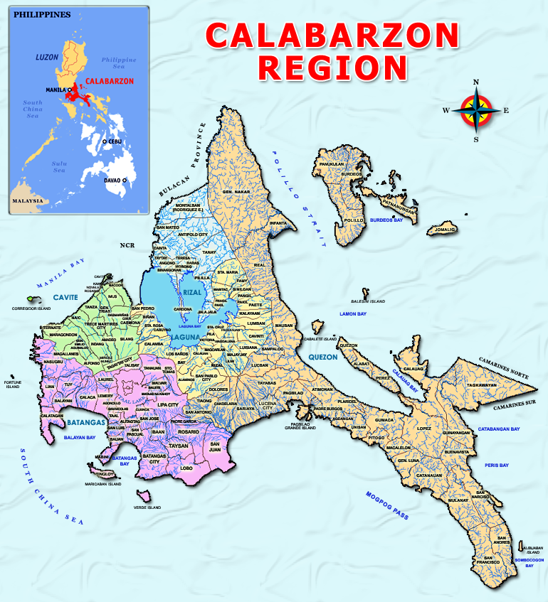
Region IV-A also known as CALABARZON was created by virtues of EXECUTIVE ORDER 103 which was approved on May 17, 2002, creating Region IV A and Region IV-B and transferring the province of Aurora under the territorial and administrative jurisdiction of Region III. The region is located in south-western part of Luzon, just south and east of Metro Manila, on the east by the Philippine Sea and Bicol Region, on the south by Verde Island Passage, and on the west by Luzon Sea. It is practically accessible via all types of land transportation.
CALABARZON consists of five (5) provinces, thirty one (31) congressional districts, twenty (20) cities, one hundred twenty two (122) municipalities, and four thousand nineteen (4,019) barangays. The 20 cities of the region are: Antipolo City (Rizal), Bacoor City (Cavite); Cavite City (Cavite); Imus City (Cavite); Trece Martirez City (Cavite); Tagaytay City (Cavite); Dasmariñas City (Cavite); General Trias City (Cavite); City of Biñan (Laguna); Cabuyao City (Laguna); Calamba City (Laguna); San Pablo City (Laguna); San Pedro (Laguna); Sta. Rosa City (Laguna); Batangas City (Batangas); Lipa City (Batangas); Tanauan City (Batangas); Sto. Tomas City (Batangas); Lucena City (Quezon); and Tayabas City (Quezon). Quezon province has the most number of municipalities and barangays while Rizal province has the least.
| POLITICAL SUBDIVISION OF REGION IV-A | |||||
| Province |
Provincial Capital |
Number |
|||
| Congressional Districts |
Cities |
Municipalities |
Barangays |
||
| Batangas | Batangas City | 6 | 4 | 31 | 1,078 |
| Cavite | Trece Martirez City | 8 | 7 | 16 | 829 |
| Laguna | Sta. Cruz | 7 | 6 | 23 | 681 |
| Quezon | Lucena City | 4 | 2 | 39 | 1,242 |
| Rizal | Antipolo City | 6 | 1 | 13 | 189 |
| Total | 31 | 20 | 122 | 4,019 | |
TOPOGRAPHY AND SLOPE
CALABARZON has varied land forms. It consist partly of coastal areas and mostly upland interior areas of slightly moderate rolling or undulating plains and hills, and mountains. Almost sixty percent of the region’s land area has a slope ranging from 0-18 percent. Slope distribution by province is presented below.
| DISTRIBUTION OF SLOPE RANGE BY PROVINCE (IN HECTARE) | |||||||
| Province | Level to nearly level
(0-3%) |
Gently sloping to undulating
(3-8%) |
Moderately sloping to rolling
(8-18%) |
Strongly sloping to moderately steep
(18-30%) |
Steep hills and mountains
(30-50%) |
Very steep hills and mountains
(>50%) |
Total |
| Region | 248,356 | 189,330 | 531,583 | 47,658 | 215,538 | 390,396 | 1,622,861 |
| Batangas | 25,253 | 54,624 | 118,490 | 12,810 | 17,750 | 87,654 | 316,581 |
| Cavite | 26,603 | 30,438 | 40,330 | 7,644 | 6,154 | 17,586 | 128,755 |
| Laguna | 47,194 | 24,460 | 50,487 | 10,558 | 18,658 | 24,616 | 175,973 |
| Quezon | 141,976 | 73,360 | 289,044 | 16,314 | 139,026 | 210,940 | 870,660 |
| Rizal | 7,330 | 6,448 | 33,232 | 332 | 33,950 | 49,600 | 130,892 |
| % to Total Land Area | 15% | 12% | 33% | 3% | 13% | 24% | 100% |
| Source: NEDA-CALABARZON, Regional Physical Framework Plan | |||||||
Batangas province has a total land area of 316,581 hectares or 3,165.81 square kilometres. It covers about 20 % of the total land area of the CALABARZON and is considered the second largest province in the region. It has a unique cove-like shape coastal areas lying at the south-eastern portion of the province. It consists mostly of moderately sloping to rolling and very steep hills with scattered mountainous areas.
Cavite province has a total land area of 128,755 hectares or 1,287.55 square kilometres, situated at the southern end of the province of Rizal. It covers about 8% of the total land area of the CALABARZON. It is characterized by rolling hinterlands punctuated by hills, with shoreland fronting Manila Bay at sea level, and the rugged portion at the boundary of Batangas where Dos Picos mountains are located.
Laguna province has a total land area of 175,973 hectares or 1,759.73 square kilometres. It is the third-largest province in the region which covers about 11% of the total land area of the CALABARZON. It is considered as an inland province that comprises the largest portion of the Laguna de Bay Region where the Laguna Lake lies, the country’s largest inland water and the second-largest freshwater in Southeast Asia. It is characterized by flat and rugged terrain and its slope ranges from level to steep slope.
Quezon province has a total land area of 870,660 hectares or 8,706.60 square kilometres. It is the largest province in CALABARZON having 54% of the total land area of the region. On the other hand, it has a rugged terrain with few plains, valleys and swamps. The undulating lowlands along the coast are well-drained. The province is very narrow, with an average width of about 30 kilometers.
Rizal province has a total land of 130,892 hectares or 3,308.92 square kilometres and about 8% of the total land area of CALABARZON. Its topography is a combination of valleys and mountains, with flat low-lying areas on the western portion, rugged ridges and rolling hills that form part of the Sierra Madre ranges in the eastern portion.
DEMOGRAPHY AND ECONOMIC PROFILE
|
POPULATION AND POPULATION GROWTH RATE IN CALABARZON FROM YEAR 2015-2020 |
|||
| Province | Land Area | Population |
Population Growth Rate |
| Region | 1,622,861 | 16,195,042 |
2.48 |
| Cavite | 128,755 | 4,344,829 | 3.57 |
| Laguna | 175,973 | 3,382,193 | 2.30 |
| Batangas | 316,581 | 2,908,494 | 1.62 |
| Rizal | 130,892 | 3,330,143 | 3.07 |
| Quezon | 870,660 | 2,229,383 | 1.04 |
Based on the CY 2020 Census of Population, CALABARZON now has 16.2 million residents, the largest in the country. The population of Region IV-A increased by 2.48 percent annually from 2015 to 2020. By comparison, the rate at which the population of the region grew from 2010 to 2015 was higher at 2.58 percent. Among the five provinces comprising Region IV-A, Cavite had the biggest population in 2020 with 4,344,829 persons, followed by Laguna with 3,382,193 persons, Rizal with 3,330,143 persons, and Batangas with 2,908,494 persons. Quezon had the smallest population with 2,229,383 persons. Cavite was the fastest-growing province in the region with an annual population growth rate (PGR) of 3.57 percent from 2015 to 2020. It was followed by Rizal with a PGR of 3.07 percent, Laguna (2.30 percent) and Batangas (1.62 percent). Quezon posted the lowest provincial PGR of 1.04 percent. (source: PSA 2021 CPH)
CLIMATE
Intense variability in climate is currently being experienced all over the country. As general information, Region IV-A has all the four (4) types of climate: Type I-with two pronounced seasons, dry from November to April and wet during the rest of the year; Type II-no dry season with a very pronounced rainfall from November to April and wet during the rest of the year; Type III-seasons are not very pronounced, relatively dry from November to April and wet during the rest of the year; and Type IV-rainfall is more or less evenly distributed throughout the year. The province of Cavite has two (2) distinct seasons: wet from May to November and dry from December to April. Laguna is relatively dry from November to April and wet during the rest of the year, specifically in the small portion near the southern boundary. The eastern and southern portions of Laguna province have no distinct season but with evenly distributed rainfall throughout the year.
The province of Batangas also has two (2) distinct seasons: dry from November to April and wet during the rest of the year. On the other hand, the province of Rizal is relatively dry from December to May and wet during the rest of the year.
Quezon province has three (3) climatic types: no dry season with very pronounced rainfall from November to January and wet during the rest of the year; not very pronounced season and relatively dry from November to April and wet during the rest of the year; and more or less evenly distributed rainfall throughout the year.
- Details
- Category: About Us
- Published: 21 July 2016