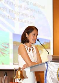
ACCEPTANCE SPEECH Delivered by Regional Executive Director Nilo B. Tamoria DENR CALABARZON, Barangay Mayapa, Calamba City May 10, 2021
Isang makakalikasang umaga po sa inyong lahat!
Sa atin pong Undersecretary for Field Operations and Environment, Undersecretary Juan Miguel T. Cuna,
Sa atin pong Assistant Regional Director for Technical Services, Alfredo Palencia,
To our Assistant Regional Director for Management Services, Nelson Gorospe,
Sa atin pong Regional Director ng Mines and Geosciences Bureau, Dondi Sarmiento
Sa mga PENRO at CENRO na narito ngayon, PENRO Noel Recillo, CENRO Januel Peras,
At sa iba pa po nating kasamahan na PENRO and CENRO na naka-Zoom,
Sa mga Division at Section Chief,
Sa bumubuo po ng DENR CALABARZON at sa lahat po ng nakatunghay sa ating programa sa field at sa Central Office,
Inuulit ko po, isang makakalikasang umaga po sa inyong lahat!
Let me start my message by expressing my utmost gratitude to all, for your warm welcome. I am honored to be here again, to serve as your Regional Executive Director.
Lilinawin ko lamang po, hindi po ako nawala sa CALABARZON dahil ang inyo pong lingkod ay tubong CALABARZON. Gaya ng pagpapakilala ng ating Assistant Regional Director, ako po ay ipinanganak sa Binangonan, Rizal at kasalukuyang iyon pa rin ang inuuwian ko at wala na po akong ibang inuuwian.
I see a lot of familiar faces online and in person. Some of you must already know me, my management style well since I have served as your RED from 2008-2011. It is definitely refreshing to be back here in Region IV-A, my home region.
Ako ay excited at ready. I am excited to attend to familiar target activities, programs, and projects. I am ready to carry on and deliver the highest quality of public service and address the current issues and concerns of the Region.
Hindi ko pa po malimutan noong naatasan po tayo ng dating Kalihim Lito Atienza. Magmula po sa Roxas Boulevard, magkasabay kami ni ASEC Mars bilang RED po siya noon ng 4B at ako ng 4A na pinalipat po at i-comply na lumipat sa mga Regional Government Center. Noong umpisa po, marami ang medyo hindi masaya dahil malilipat ng lugar. Nakaraan po ng labintatlong taon, narito na po tayo sa napakaganda nating tanggapan. At ‘yung Region 4B, with due respect sa Region 4B leadership, naandun pa rin po sa Roxas Boulevard.
Sixteen years since I entered DENR in 2004. Thirteen years since I was designated as Regional Executive Director of Region 4A in 2008, my first regional assignment as Director IV. Ten years since I left Region 4A to NCR, and nine years since I started to serve my dismissal from the service. And five years since I returned back (to) work after winning my case all the way from Court of Appeals to Supreme Court. And two years since my last assignment as RED of Region 12 na nagkataon, ‘yung pumalit po sa akin sa Region 4A ay pinalitan ko sa Region 12, si dating RED Rey Juan.
All those years, (there were) a lot of blessings. Marami pong blessing ang (aking) tinamo sa personal at propesyonal na buhay. Finally, na-confer na po ako bilang CESO, finally, this year sa (loob ng) mahigit na labindalawang taon.
Dala dala ko ang aking dagdag na eksperyensa sa lahat ng dinaan ko po magmula po noong panandaliang iwan ko ang Region 4A. Napakarami po ang napakayamang karanasan sa usapin ng pagpapalakad at pamumuno po sa ating ahensya sa iba’t ibang kapasidad, at ang nakaraan pong karanasan natin bilang Executive Director ng Environmental Protection and Enforcement Task Force. Bilang panimula para doon sa nilalayon nating pang-matagalang pagpapalakas ng enforcement mandate ng DENR, ang pagtatatag ng Environmental Protection and Enforcement Bureau ay malaking dagdag na dala at bitbit ng inyong lingkod sa pag-assume ng Regional Executive Director post dito sa CALABARZON. I commit to organize, manage, and utilize all our resources efficiently especially during these very challenging times as we navigate the new normal.
Ayon po kay Peter Drucker, isang eksperto na gumawa sa konsepto ng Management by Objectives, “Leadership is lifting a person's vision to high sights, the raising of a person's performance to a higher standard, the building of a personality beyond its normal limitations.”
So, kasama ko po ang aking dalawang mahuhusay na Assistant Regional Directors, ARD Fred Palencia and ARD Nelson Gorospe, kayo pong magigiting na empleyado ng DENR CALABARZON ang aming magiging katuwang. I aim for the improvement not only of our services, but most importantly, of our workforce. We can only be effective and productive if we, ourselves, are equipped with the needed skills and knowledge, and are physically, emotionally and mentally healthy. At syempre po, ‘yung pagkakaisa natin sa tunguhin at bisyon ng ating ahensya, ayun po ang pinakaimportante sa atin.
Pagtulungan po natin ito. I look forward to getting reacquainted to build a conducive working relationship with all of you. Sa lahat po ng bumubuo ng DENR magmula po sa ating Kalihim Roy A. Cimatu, sa mga Undersecretaries po, kay USEC Cuna po na ating supervising USEC ng field operations, salamat po sa pagtiwala na mailagay muli dito sa Region 4A CALABARZON bilang Regional Executive Director.
Again, maraming, maraming salamat po at mabuhay tayong lahat! Magandang umaga po sa inyong lahat.
NILO B. TAMORIA Regional Executive Director Department of Environment and Natural Resources IV-A (CALABARZON)
RED Nilo B. Tamoria has spent more than 25 years of supervisory experience and 15 years in managing environmental programs. He has held various key positions such as Regional Executive Director of Region XII and NCR, Executive Director for Special Concerns as well as Environmental Protection and Enforcement Task Force (EPETF).
RED Nilo is a Career Executive Officer III and is considered an innovative team leader and motivator who promotes the team’s personal development and productivity. Some of his areas of expertise are Project Management and Strategic Planning, Land Administration Management, Community Organizing and Development, Stakeholder Participation, and Environmental Law Enforcement.
RED Nilo has led DENR CALABARZON from 2008 to 2012, and now he is again designated as Regional Executive Director of the DENR CALABARZON pursuant to the DENR Special Order No. 2021-223 signed by Environment Secretary Roy A. Cimatu on May 3, 2021.
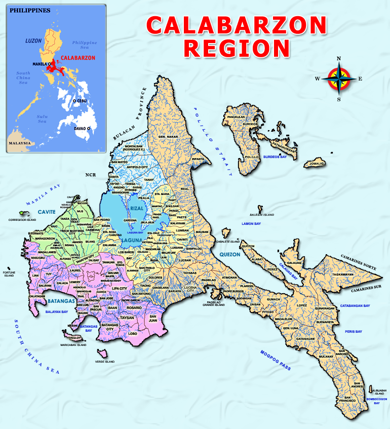
Region IV-A also known as CALABARZON was created by virtues of EXECUTIVE ORDER 103which was approved on May 17, 2002, creating Region IV A and Region IV-B and transferring the province of Aurora under the territorial and administrative jurisdiction of Region III. The region is located in south-western part of Luzon, just south and east of Metro Manila, on the east by the Philippine Sea and Bicol Region, on the south by Verde Island Passage, and on the west by Luzon Sea. It is practically accessible via all types of land transportation.
CALABARZON consists of five (5) provinces, thirty one (31) congressional districts, twenty (20) cities, one hundred twenty two (122) municipalities, and four thousand nineteen (4,019) barangays. The 20 cities of the region are: Antipolo City (Rizal), Bacoor City (Cavite); Cavite City (Cavite); Imus City (Cavite); Trece Martirez City (Cavite); Tagaytay City (Cavite); Dasmariñas City (Cavite); General Trias City (Cavite); City of Biñan (Laguna); Cabuyao City (Laguna); Calamba City (Laguna); San Pablo City (Laguna); San Pedro (Laguna); Sta. Rosa City (Laguna); Batangas City (Batangas); Lipa City (Batangas); Tanauan City (Batangas); Sto. Tomas City (Batangas); Lucena City (Quezon); and Tayabas City (Quezon). Quezon province has the most number of municipalities and barangays while Rizal province has the least.
POLITICAL SUBDIVISION OF REGION IV-A
Province
Provincial Capital
Number
Congressional Districts
Cities
Municipalities
Barangays
Batangas
Batangas City
6
4
31
1,078
Cavite
Trece Martirez City
8
7
16
829
Laguna
Sta. Cruz
7
6
23
681
Quezon
Lucena City
4
2
39
1,242
Rizal
Antipolo City
6
1
13
189
Total
31
20
122
4,019
TOPOGRAPHY AND SLOPE
CALABARZON has varied land forms. It consist partly of coastal areas and mostly upland interior areas of slightly moderate rolling or undulating plains and hills, and mountains. Almost sixty percent of the region’s land area has a slope ranging from 0-18 percent. Slope distribution by province is presented below.
DISTRIBUTION OF SLOPE RANGE BY PROVINCE (IN HECTARE)
Province
Level to nearly level
(0-3%)
Gently sloping to undulating
(3-8%)
Moderately sloping to rolling
(8-18%)
Strongly sloping to moderately steep
(18-30%)
Steep hills and mountains
(30-50%)
Very steep hills and mountains
(>50%)
Total
Region
248,356
189,330
531,583
47,658
215,538
390,396
1,622,861
Batangas
25,253
54,624
118,490
12,810
17,750
87,654
316,581
Cavite
26,603
30,438
40,330
7,644
6,154
17,586
128,755
Laguna
47,194
24,460
50,487
10,558
18,658
24,616
175,973
Quezon
141,976
73,360
289,044
16,314
139,026
210,940
870,660
Rizal
7,330
6,448
33,232
332
33,950
49,600
130,892
% to Total Land Area
15%
12%
33%
3%
13%
24%
100%
Source: NEDA-CALABARZON, Regional Physical Framework Plan
Batangas province has a total land area of 316,581 hectares or 3,165.81 square kilometres. It covers about 20 % of the total land area of the CALABARZON and is considered the second largest province in the region. It has a unique cove-like shape coastal areas lying at the south-eastern portion of the province. It consists mostly of moderately sloping to rolling and very steep hills with scattered mountainous areas.
Cavite province has a total land area of 128,755 hectares or 1,287.55 square kilometres, situated at the southern end of the province of Rizal. It covers about 8% of the total land area of the CALABARZON. It is characterized by rolling hinterlands punctuated by hills, with shoreland fronting Manila Bay at sea level, and the rugged portion at the boundary of Batangas where Dos Picos mountains are located.
Laguna province has a total land area of 175,973 hectares or 1,759.73 square kilometres. It is the third-largest province in the region which covers about 11% of the total land area of the CALABARZON. It is considered as an inland province that comprises the largest portion of the Laguna de Bay Region where the Laguna Lake lies, the country’s largest inland water and the second-largest freshwater in Southeast Asia. It is characterized by flat and rugged terrain and its slope ranges from level to steep slope.
Quezon province has a total land area of 870,660 hectares or 8,706.60 square kilometres. It is the largest province in CALABARZON having 54% of the total land area of the region. On the other hand, it has a rugged terrain with few plains, valleys and swamps. The undulating lowlands along the coast are well-drained. The province is very narrow, with an average width of about 30 kilometers.
Rizal province has a total land of 130,892 hectares or 3,308.92 square kilometres and about 8% of the total land area of CALABARZON. Its topography is a combination of valleys and mountains, with flat low-lying areas on the western portion, rugged ridges and rolling hills that form part of the Sierra Madre ranges in the eastern portion.
DEMOGRAPHY AND ECONOMIC PROFILE
POPULATION AND POPULATION GROWTH RATE IN
CALABARZON FROM YEAR 2015-2020
Province
Land Area
Population
Population
Growth Rate
Region
1,622,861
16,195,042
2.48
Cavite
128,755
4,344,829
3.57
Laguna
175,973
3,382,193
2.30
Batangas
316,581
2,908,494
1.62
Rizal
130,892
3,330,143
3.07
Quezon
870,660
2,229,383
1.04
Based on the CY 2020 Census of Population, CALABARZON now has 16.2 million residents, the largest in the country. The population of Region IV-A increased by 2.48 percent annually from 2015 to 2020. By comparison, the rate at which the population of the region grew from 2010 to 2015 was higher at 2.58 percent. Among the five provinces comprising Region IV-A, Cavite had the biggest population in 2020 with 4,344,829 persons, followed by Laguna with 3,382,193 persons, Rizal with 3,330,143 persons, and Batangas with 2,908,494 persons. Quezon had the smallest population with 2,229,383 persons. Cavite was the fastest-growing province in the region with an annual population growth rate (PGR) of 3.57 percent from 2015 to 2020. It was followed by Rizal with a PGR of 3.07 percent, Laguna (2.30 percent) and Batangas (1.62 percent). Quezon posted the lowest provincial PGR of 1.04 percent. (source: PSA 2021 CPH)
CLIMATE
Intense variability in climate is currently being experienced all over the country. As general information, Region IV-A has all the four (4) types of climate: Type I-with two pronounced seasons, dry from November to April and wet during the rest of the year; Type II-no dry season with a very pronounced rainfall from November to April and wet during the rest of the year; Type III-seasons are not very pronounced, relatively dry from November to April and wet during the rest of the year; and Type IV-rainfall is more or less evenly distributed throughout the year. The province of Cavite has two (2) distinct seasons: wet from May to November and dry from December to April. Laguna is relatively dry from November to April and wet during the rest of the year, specifically in the small portion near the southern boundary. The eastern and southern portions of Laguna province have no distinct season but with evenly distributed rainfall throughout the year.
The province of Batangas also has two (2) distinct seasons: dry from November to April and wet during the rest of the year. On the other hand, the province of Rizal is relatively dry from December to May and wet during the rest of the year.
Quezon province has three (3) climatic types: no dry season with very pronounced rainfall from November to January and wet during the rest of the year; not very pronounced season and relatively dry from November to April and wet during the rest of the year; and more or less evenly distributed rainfall throughout the year.
The Department of Environment and Natural Resources (DENR) through Executive Order 192, Series of 1987 is mandated to be the government agency primarily responsible for the conservation, management, development, and proper use of the country’s environment and natural resources, specifically forest and grazing lands, mineral resources, including those in reservation and watershed areas, and lands of the public domain, as well as the licensing and regulation of all natural resources as may be provided for by law in order to ensure equitable sharing of the benefits derived therefrom for the welfare of the present and future generations of Filipinos.
VISION
A nation enjoying and sustaining its natural resources and a clean and healthy environment.
MISSION
To mobilize our citizenry in protecting, conserving, and managing the environment and natural resources for the present and future generations.
CORE FUNCTION
DENR is tasked to formulate and implement policies, guidelines, rules and regulations relating to environmental management and pollution prevention and control.
DENR has to formulate, implement and supervise the government’s policies, plans and programs pertaining to the management, conservation, development, use and replenishment of the country’s natural resources and biological diversity.
Further, we promulgate and implement rules and regulations governing the exploration, development, extraction, disposition, and use of our forests, lands, minerals, wildlife and other natural resources.
PRIORITIES AND POLICY DIRECTIONS
To sustain the President’s 0 + 10 Point Socio-Economic Agenda as envisioned in Memorandum Circular No. 12 (Directing the Formulation of the Philippine Development Plan and the Public Investment Program for the period 2017-2022 dated October 24, 2016.
Strengthen multi-year focus of the budget, including the acceleration of infrastructure spending from 5% of GDP.
Provide full support to the poorest, lagging and most climate vulnerable areas.
Strengthen M&E through the Result-based Monitoring, Evaluation and Reporting (RbMER) Policy Framework.
MAJOR THRUSTs AND PRIORITIES
The Department’s thrust and priorities are anchored on a 5-point agenda:
Poverty reduction and hunger mitigation
Socio-economic development
Natural resources conservation
Climate change mitigation and adaptation measures
Environmental education and enforcement
With these, the following are the Ten (10) Priority Programs of the agency:
Clean Air
Clean Water
Solid Waste Management
Geo-hazard, Groundwater Assessment and Responsible Mining
Forest and Watershed Management
Intensified Forest Protection and Anti-illegal Logging
Enhanced Biodiversity Conservation
Scaling up of Coastal and Marine Ecosystem
Improved Land Administration and Management
Manila Bay Clean up
The different development frameworks such as the Sustainable Development Goals under United Nations, Philippine Long Term Vision-Ambisyon Natin 2040, Philippine Development Plan 2017-2022 and the Program for Environment and Natural Resources for Restoration, Rehabilitation and Development (PRRD) are bases of afore-mentioned programs implementation towards “MATATAG, MAGINHAWA AT PANATAG NA BUHAY”.